 Our pilot, Darren, gave us a quick safety talk, and we were on our way. From the air one can see that human habitation falls off quickly as one travels north of Fairbanks. There are a few roads initially, but soon there is only one - the Dalton Highway, which roughly parallels the Trans-Alaska pipeline.
As we traveled North, we could see the White Mountains on our right, and then we saw the streams, creeks and tributaries that led to the Yukon River. If I remember geology correctly, older rivers tend to be much more curvy, with lots of switchbacks. If this is true, all of the rivers and creeks we saw must be pretty old, because they reminded me of cursive writing from the air.
The hills and valleys near Fairbanks had patches of snow, but as we travelled further north, the hills got rougher and more snow covered. Darren pointed out various land features and would bank the wings so we could get a better look. We flew low, relative to the ground, and got a little battering from the winds off the hills.
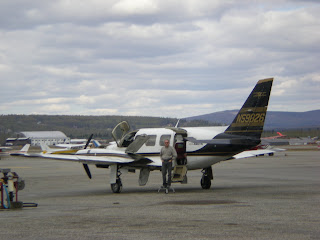
 After about an hour of flight time, we landed at the Coldfoot Air Strip, and that was exciting. The air strip is in a valley next to the Koyakuk River, and the wind rocked us back and forth as we headed down. There were no casualties, but we felt just a little green after landing. We met George, our guide, and got in a van for the next part of the trip. We stopped at the Coldfoot truck stop, the last source of fuel south of Prudhoe Bay, 240 miles north by road. We rode on the Dalton Highway to the community of Wiseman. The Dalton Highway is a packed gravel road, wide enough for two trucks to pass. There isn't much shoulder separating the driver from the tundra.
Wiseman is a very small community of extremely independent people. They live totally off the grid, but do have phone and internet links to the rest of the world. A trip to Fairbanks takes over six hours one way, so they seldom go to town. One resident, Jack, is a guide trainer for the tour company, and was kind enough to let us visit his home. Let's just say we couldn't live as he does.
 On our way back to Coldfoot, we came across a couple of moose grazing near the road. George backed up (although he isn't supposed to) to allow picture taking. The moose weren't particularly cooperative, so the pictures mostly show brush. (I'll try to edit those and post them when we get back!)
We had a brief stop at Coldfoot, and got back on the plane. The ride south was smoother than the ride north since Darren took us to higher altitude. The skies above Coldfoot and Wiseman were clear and blue, but we got back under clouds as we approached Fairbanks. On landing, we were awarded our certificates for travelling above the Arctic Circle.
After supper, it didn't take long to get to sleep. Jet lag, the excitement of the day, and Dramamine all acted to knock us out.

Wow, this is great!
ReplyDelete